I thought it might interest some folks on here to see how you could possibly travel around the USA and never go that far above or below 70 degrees ")
From Brian B's Climate Blog
----------------------------------------------------

In all my (many) years of making maps, the most popular by far is the 70°F Road Trip map that I originally produced in 2015. It's been shared over 10 million times on various platforms if I had to guess. Maybe 20 million. That map was a hypothetical trip through the U.S. with the route tracking where the normal daily high temperature was approximately 70°F (21°C). I have been contacted numerous times over the years since from people who want to bike or drive the trip. It has resonated with people in a way I never imagined.
The map was based on the 1981-2010 climate normals produced by the National Center for Environmental Information (NCEI). Every 10 years, new climate normals are produced. In May 2021, the 1991-2020 normals were released by NCEI. Since then, I have been meaning to update the 70°F road trip map with the new normals. Several people have asked about it over the last two years. It might surprise people that as fast as the globe is warming up due to human activity, the shift in 70°F temperatures between 1981-2010 and 1991-2020 is very slight. It's just too short of a time period to capture the distance change. Instead, I decided to come up with new routes. The original route was interesting, but it left out a lot of options. This time around, there are multiple routes to choose from. Enjoy!
Continuous U.S.:
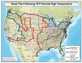
There are two routes this time (and a combined route), 1) Coastal Route, and 2) Interior Route.
1) Coastal Route - This route begins in Florida, goes up counter-clockwise to the Pacific Northwest before winding its way through the Intermountain West before reaching San Diego. (7,468 miles)
2) Interior Route - This route begins in south Texas and works its way northward to near the Canadian border. It then heads east before working through the northern Rockies, before heading south through the western Great Plains and then heading through the Desert Southwest. (7,064 miles)
2B) Combined Interior Route that connects with Coastal Route - In mid/late March, head northeast to connect with the Coastal Route and follow that route the rest of the way. (8,466 miles)
All U.S. and Canada:

The U.S. - Canada version is quite a bit longer (of course). Since Canada still (!!!) has not published 1991-2020 normals, I took the liberty of computing them myself using the "old method" of fitting a 3rd-order polynomial spline to the monthly averages. It's not perfect, but it is pretty close.
The big difference with the U.S. - Canada map is that the route stays on non-interstate highways as much as possible. Also, they cross each other in Arkansas. This may be a little confusing. Otherwise, the map should be straightforward.
 us-climate.blogspot.com
From Brian B's Climate Blog
----------------------------------------------------
In all my (many) years of making maps, the most popular by far is the 70°F Road Trip map that I originally produced in 2015. It's been shared over 10 million times on various platforms if I had to guess. Maybe 20 million. That map was a hypothetical trip through the U.S. with the route tracking where the normal daily high temperature was approximately 70°F (21°C). I have been contacted numerous times over the years since from people who want to bike or drive the trip. It has resonated with people in a way I never imagined.
The map was based on the 1981-2010 climate normals produced by the National Center for Environmental Information (NCEI). Every 10 years, new climate normals are produced. In May 2021, the 1991-2020 normals were released by NCEI. Since then, I have been meaning to update the 70°F road trip map with the new normals. Several people have asked about it over the last two years. It might surprise people that as fast as the globe is warming up due to human activity, the shift in 70°F temperatures between 1981-2010 and 1991-2020 is very slight. It's just too short of a time period to capture the distance change. Instead, I decided to come up with new routes. The original route was interesting, but it left out a lot of options. This time around, there are multiple routes to choose from. Enjoy!
Continuous U.S.:
There are two routes this time (and a combined route), 1) Coastal Route, and 2) Interior Route.
1) Coastal Route - This route begins in Florida, goes up counter-clockwise to the Pacific Northwest before winding its way through the Intermountain West before reaching San Diego. (7,468 miles)
- January - Begin in Tampa, Florida, and slowly head east toward Orlando. (151 miles)
- February - Head up the east coast of Florida to Jacksonville. (81 miles)
- March - Continue northward along I-95 to just past the N. Carolina border. (341 miles)
- April - Keep on I-95 northbound to Philadelphia area. (447 miles)
- May - The last segment of I-95 takes you to the Boston area. (300 miles)
- June - Things change really fast in the summer. It's nearly impossible to beat the 70°F isotherm. That said, you work your way from Bost over to Buffalo, then Cleveland, then Detroit, through the Upper Peninsula of Michigan, and all the way to central Montana. Most of this section needs to be done in early June. (2,388 miles)
- July - Most of the July segment follows I-90 through western Montana, Idaho, and then to Seattle. The end of month point is along the coast. (965 miles)
- August - Head south along the coastal highway to Newport, Oregon. (289 miles)
- September - This month involves a lot of lesser traveled mountain highways though eastern Oregon. Then you pick up I-84 in Idaho and eventually I-15 in Utah. (962 miles)
- October - Follow a series of rural highways southeast to Albuquerque. (546 miles)
- November - Go west along I-40 to Flagstaff and then south along I-17 to Phoenix. (467 miles)
- December - Take I-8 from Phoenix to Los Angeles and then I-5 to San Diego. (531 miles)
2) Interior Route - This route begins in south Texas and works its way northward to near the Canadian border. It then heads east before working through the northern Rockies, before heading south through the western Great Plains and then heading through the Desert Southwest. (7,064 miles)
- January - Start in Brownsville, Texas, and head north to Corpus Christi, Texas. (140 miles)
- February - Follow the Texas coastal bend to Houston. (197 miles)
- March - Take US 59 north to Dallas and then I-35 to Oklahoma City. (408 miles)
- April - Head north and then northeast to Kansas City. (343 miles)
- May - Continue north to Des Moines, east to Rockford, then northwest to Minneapolis. (765 miles).
- June - Go north to Duluth and then head east toward central Montana. Most of this section needs to be done in early June. (1,062 miles - 923 are shared with the Coastal Route)
- July - Head southeast, and then at Butte, Montana, go to Yellowstone National Park and continue through western Montana, northwestern Colorado, and back into south central Wyoming. We have to take this circuitous route to stay in the high country. (1,255 miles - 202 are shared with the Coastal Route)
- August - Slowly move from south to north through central Wyoming and back into extreme southern Montana. (384 miles).
- September - Go due east until reaching the southwestern corner of North Dakota and turn south - until the Nebraska border. (533 miles)
- October - Continue nearly due south to the Texas panhandle and turn southwest to head toward Cloudcroft, New Mexico. (1,047 miles)
- November - Head nearly due east on state and U.S. highways until Phoenix. (399 miles)
- December - This last segment from Phoenix to San Diego is 100% shared with the Coastal Route. (531 miles).
2B) Combined Interior Route that connects with Coastal Route - In mid/late March, head northeast to connect with the Coastal Route and follow that route the rest of the way. (8,466 miles)
- January - Start in Brownsville, Texas, and head north to Corpus Christi, Texas. (140 miles)
- February - Follow the Texas coastal bend to Houston. (197 miles)
- March - Take US 59 north to Dallas and then turn east on I-30 to Little Rock. (553 miles)
- April - Head east-northeast to Memphis, Nashville, and eventually Washington D.C. (1,128 miles - 91 are shared with the Coastal Route)
- May - The last segment of I-95 takes you to the Boston area. (300 miles)
- June - Things change really fast in the summer. It's nearly impossible to beat the 70°F isotherm. That said, you work your way from Bost over to Buffalo, then Cleveland, then Detroit, through the Upper Peninsula of Michigan, and all the way to central Montana. Most of this section needs to be done in early June. (2,388 miles)
- July - Most of the July segment follows I-90 through western Montana, Idaho, and then to Seattle. The end of month point is along the coast. (965 miles)
- August - Head south along the coastal highway to Newport, Oregon. (289 miles)
- September - This month involves a lot of lesser traveled mountain highways though eastern Oregon. Then you pick up I-84 in Idaho and eventually I-15 in Utah. (962 miles)
- October - Follow a series of rural highways southeast to Albuquerque. (546 miles)
- November - Go west along I-40 to Flagstaff and then south along I-17 to Phoenix. (467 miles)
- December - Take I-8 from Phoenix to Los Angeles and then I-5 to San Diego. (531 miles)
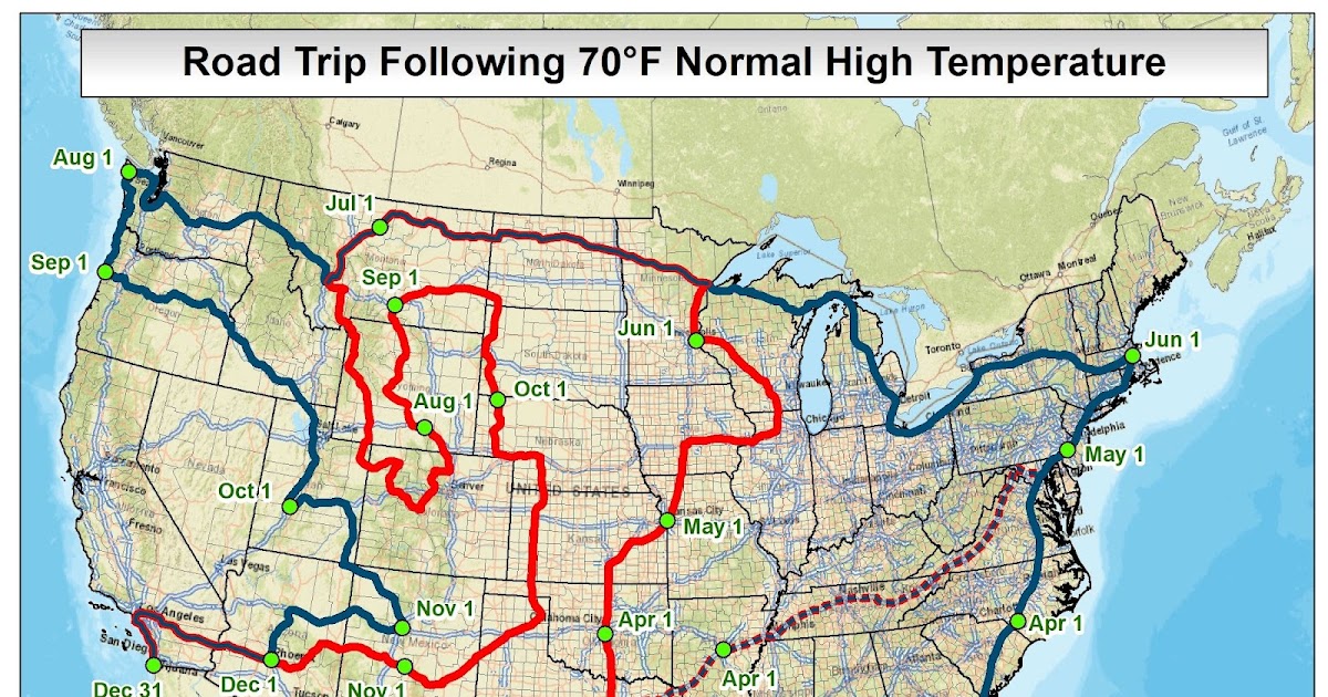
All U.S. and Canada:
The U.S. - Canada version is quite a bit longer (of course). Since Canada still (!!!) has not published 1991-2020 normals, I took the liberty of computing them myself using the "old method" of fitting a 3rd-order polynomial spline to the monthly averages. It's not perfect, but it is pretty close.
The big difference with the U.S. - Canada map is that the route stays on non-interstate highways as much as possible. Also, they cross each other in Arkansas. This may be a little confusing. Otherwise, the map should be straightforward.
- January - Start in San Diego and stay on I-8 to Phoenix. (357 miles - 575 km)
- February - Follow I-10 to El Paso (384 miles - 618 km)
- March - From El Paso, we stay on local state roads to about Wichita Falls, TX, and then through extreme southern and extreme eastern Oklahoma (991 miles - 1,596 km)
- April - Head east through Arkansas, all of southern Tennessee, into N. Carolina and up the Blue Ridge Parkway, then through western Virginia, W. Virginia, and finally to Pittsburgh. (1,328 miles - 2,138 km)
- May - Start eastward for about 100 miles before looping back westward toward Youngstown and Canton, OH, turn northeast to Chicago, IL, then north into Wisconsin, and finally west to central Minnesota. (1,440 miles - 2,318 km).
- June - Continuing northward, you reach the international border at International Falls, MN. Follow the highway north to Longbow Lake and then west to Winnipeg and Edmonton. Keep heading northeast and then north on smaller highways to Hay River on the shore of Great Slave Lake. From there, head generally west toward Dawson, YT, and the border crossing at the Top of the World Highway. Then make your way to Fairbanks, AK. (3,424 miles - 5,513 km)
- July - Head south from Fairbanks to just north of Anchorage and continue eastward to the Canadian border. Take the western route to the Lower 48. By the end of the month find your way to Prince George, BC. (1,735 miles - 2,793 km)
- August - From Prince George, head southeast to Calgary and cross back into the U.S. near Glacier National Park. (643 miles - 1,035 km).
- September - Stay on smaller highways that head south through parts of western Wyoming and eastern Idaho and then northeastern Utah. Briefly take I-70 east to the Colorado Border. (1,056 miles - 1,700 km)
- October - In Colorado, head southeast on state and U.S. highways into extreme northern New Mexico near Taos. Then head north and northeast to Denver and then east into the plains of eastern Colorado. Then continue eastward through most of southern Kansas before turning southeast to Little Rock, AR. This is where the route crosses itself from early April. (1,632 miles - 2,628 km)
- November - Head nearly due east to Jackson, MS, then up to Birmingham, AL, and then southeast to Lake City, FL. (732 miles - 1,179 km)
- December - This last segment is from Lake City, FL, to Daytona, FL. (187 miles - 301 km).
70°F Road Trip version 2.0 (2023)
In all my (many) years of making maps, the most popular by far is the 70°F Road Trip map that I originally produced in 2015. It's been sha...
us-climate.blogspot.com