You are using an out of date browser. It may not display this or other websites correctly.
You should upgrade or use an alternative browser.
You should upgrade or use an alternative browser.
Thread Deleted
- Thread starter vajrabond
- Start date
ali
Well-known member
Looking forward to it! You were an inspiration to me last season, and i'm still thinking about maybe trying to get out there and do some short legs at least after the vaccine becomes available. I hope you still post here, since i don't really follow socials. I'll drop some change 
MetalBryan
Well-known member
Can I ask why you chose the bikepacking style seat post bag as opposed to a rear rack, trunk, and panniers? It's okay if the answer is "that's what I have" I'm just slowly outfitting my bike for touring and haven't pulled the trigger on front or rear rack systems.
Thread deleted
Last edited:
MetalBryan
Well-known member
If you find my last threads, you'll see I used to use a full Ortlieb set of giant panniers and even a trunk bag for the last couple of years of touring. Sometimes having 70-100 pounds of stuff strapped to my bike. I went with a more bikepacking design after following other adventurers online and seeing how they switched to a more minimalist kit. My experience was 30-40% of the crap I carried on a loaded bike, I hardly used and often carried out of fears or what ifs. I've now moved from 60-80 pound kit to about 35 pounds. Also on a loaded bike, something people don't tell you is how much quicker chains/rings wear out if you are doing a lot of climbing. Less weight means less drive train wear. It was also mentally exhausting to be going 6mph uphill and maxing at 8-12mph on flats. Basically a lighter bike shaves hours, effort, and wear off the touring life. The bikepacking bags are also more aerodynamic than bulky panniers adding to that. The sacrifices are some lightweight stuff is more expensive and less glamorous. You can't have a bikepacking kit if you have bulky gear, so lots had to change like a bivy instead of a big tent for me. Hydration bladders instead of several bottles. Packable clothes. This will be my first time going the distance with a kit like this, but I think I'm going to like it a lot more. My idea was to care less about the camping aspect and more about the riding/ filming. Stealth camping in a bivy looking up at the stars on an inflatable bed is it's own luxury, but it feels vulnerable. It will make the occasional motel or WarmShowers hosting spot all the sweeter though.
Thanks for laying out the details. I did see the "old" setup with the panniers and thought that it was probably a natural progression of ditching what you never needed... but I hadn't considered prioritizing riding vs camping. That's super helpful thinking about what I will need going forward.
Dunedrifter
New member
I find this link National Snow Analyses - NOHRSC - The ultimate source for snow information - https://www.nohrsc.noaa.gov/nsa/ really useful to find out where there’s still snow. Use the dropdown menu to choose your region for a closer view.
I find it’s better just to look up the highway and the national park for info. This would be handy for trails, but the highways could have 20 feet piled up on either side but be plowed/ salted. Lassen for instance has an updated plowing map. One of the advantages of riding the Sierra Cascades over hiking the Pacific Crest Trail.I find this link National Snow Analyses - NOHRSC - The ultimate source for snow information - https://www.nohrsc.noaa.gov/nsa/ really useful to find out where there’s still snow. Use the dropdown menu to choose your region for a closer view.
Dunedrifter
New member
Yeah, that makes sense. I use it for off-highway riding. I hope you’re enjoying Plumas County, my birthplaceI find it’s better just to look up the highway and the national park for info. This would be handy for trails, but the highways could have 20 feet piled up on either side but be plowed/ salted. Lassen for instance has an updated plowing map. One of the advantages of riding the Sierra Cascades over hiking the Pacific Crest Trail.

MetalBryan
Well-known member
Good luck on the trip! I watched your gear video on youtube - thank you for being so thorough!
I used some of my stimmy to get that Brooks B17. A friend said you can ride it in the rain to break it in, but I also got their Proofide because I wanted to treat the leather right. I needed a saddle upgrade when I started doing 50mil/day or I probably wouldn't have gotten it, but I've put ~100 miles on it and I can tell it's gonna be great... those first 20 miles were really hard on my ass though, so be prepared. Brooks raised their prices recently - REI still has a few left for a "lower" price.
I used some of my stimmy to get that Brooks B17. A friend said you can ride it in the rain to break it in, but I also got their Proofide because I wanted to treat the leather right. I needed a saddle upgrade when I started doing 50mil/day or I probably wouldn't have gotten it, but I've put ~100 miles on it and I can tell it's gonna be great... those first 20 miles were really hard on my ass though, so be prepared. Brooks raised their prices recently - REI still has a few left for a "lower" price.
Been out for a few days, but I suppose before I post anything else I should share the news: I’m a finalist for the Lael Rides Alaska scholarship that will send two people on an expenses paid trip to cycle around Alaska this summer.
Last edited:
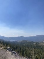
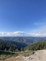
From Truckee to Redding highlights!
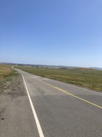
scenic route 20 mountain views:
View attachment 65558
View attachment 65559
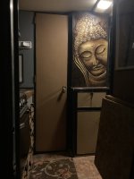
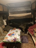
I stayed in a real cool camper in Nevada City via WarmShowers
View attachment 65560
View attachment 65561
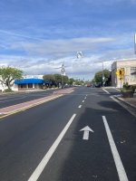
The downhills and flats to chico are nice
View attachment 65562
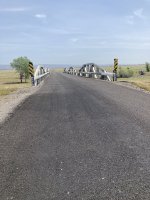
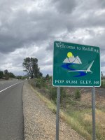
As were the ones on the way to Redding
View attachment 65563
View attachment 65564
View attachment 65565
scenic route 20 mountain views:
View attachment 65558
View attachment 65559
I stayed in a real cool camper in Nevada City via WarmShowers
View attachment 65560
View attachment 65561
The downhills and flats to chico are nice
View attachment 65562
As were the ones on the way to Redding
View attachment 65563
View attachment 65564
View attachment 65565
Attachments
-
 332690C1-FCC1-4D32-A58B-1719B560A104.jpeg469.5 KB · Views: 867
 -
 B713FFF4-4F77-4A40-871E-BD3820F899D0.jpeg522.4 KB · Views: 858
 -
 231DF33E-8CB8-4838-9E56-DA02CB118B99.jpeg388.5 KB · Views: 900
 -
 AF21EE0C-2BFD-45FF-AFD0-DD5829767883.jpeg643.9 KB · Views: 875
 -
 AD598B72-F1F4-46DF-8E2F-0586370A4396.jpeg582.5 KB · Views: 858
 -
 8AC5B386-EE38-4E5C-82C8-C8F8EC72F7FA.jpeg1 MB · Views: 867
 -
 B7C9D335-388D-49EF-96F3-B23759723452.jpeg498.5 KB · Views: 871
 -
 647A1973-AF2B-488E-B0A0-A4875AA9C035.jpeg716.6 KB · Views: 888
Currently staying with some friends in Eugene, OR. Be here a little less than a week. Didn’t end up winning any of the scholarships I was a finalist for. Heck, no big time people involved even boosted my content. That aside, lower Oregon was pretty.

I was holding out on upgrading my current bike in hopes of winning another.

I deserve nice things and the bike shop in Ashland happened to have a whole new drivetrain much better suited to climbing and pedaling long distances at high cadence.
 There is a bike path going from Ashland to Medford that gets prettier as you go.

Painted bridge in Medford toward the end.

From Medford I took a WarmShowers host recommended route, cutting through farmland to an area that was mostly National Forest and BLM areas. If you route from Medford to GalesVille Reservoir, you’ll probably get something close to my route.

Low traffic with only the occasional car camper or log truck.
 This campground was super nice and free with no one else camping. It had a pit toilet and a trail that goes back to a big creek to bathe/ filter water from.

The GalesVille Reservoir
 After how ignorant sheriffs were on the Interstate in Cali, Oregon was quite a relief. Not only did they have bike alternates and signs, a few bridges along the way up to Roseburg had separate bike bridges built under I-5, which I had no idea existed.

I got a cheap motel in Roseburg at a Super 8. Best stay of my trip so far, until I got a $100 fee the next day for ‘smoking in my room,’ even though I haven’t smoked in 2 years. Called and gave them a piece of my mind about it and fortunately was refunded the whole thing a couple days later.

Had a long day from Roseburg to Creswell, where I had an odd little WarmShowers spot.

The place turned out to be a few tiny homes on a lot.
 Thankful for the legal place to sleep and the cold water shower though.

The next day I had only 16 miles into Eugene. Where I was planning to stay only a few days, but ended up a couple weeks while I mess around with plans and have hopes of side adventures with friends.

Hoping to skip up to Washington soon either via train or friend’s car in a few days.
I was holding out on upgrading my current bike in hopes of winning another.
I deserve nice things and the bike shop in Ashland happened to have a whole new drivetrain much better suited to climbing and pedaling long distances at high cadence.
There is a bike path going from Ashland to Medford that gets prettier as you go.Painted bridge in Medford toward the end.
From Medford I took a WarmShowers host recommended route, cutting through farmland to an area that was mostly National Forest and BLM areas. If you route from Medford to GalesVille Reservoir, you’ll probably get something close to my route.
Low traffic with only the occasional car camper or log truck.
This campground was super nice and free with no one else camping. It had a pit toilet and a trail that goes back to a big creek to bathe/ filter water from.The GalesVille Reservoir
After how ignorant sheriffs were on the Interstate in Cali, Oregon was quite a relief. Not only did they have bike alternates and signs, a few bridges along the way up to Roseburg had separate bike bridges built under I-5, which I had no idea existed.I got a cheap motel in Roseburg at a Super 8. Best stay of my trip so far, until I got a $100 fee the next day for ‘smoking in my room,’ even though I haven’t smoked in 2 years. Called and gave them a piece of my mind about it and fortunately was refunded the whole thing a couple days later.
Had a long day from Roseburg to Creswell, where I had an odd little WarmShowers spot.
The place turned out to be a few tiny homes on a lot.
Thankful for the legal place to sleep and the cold water shower though.The next day I had only 16 miles into Eugene. Where I was planning to stay only a few days, but ended up a couple weeks while I mess around with plans and have hopes of side adventures with friends.
Hoping to skip up to Washington soon either via train or friend’s car in a few days.
Last edited:
Realized after getting a notification I didn’t post anything from my time out on the peninsula or that I rode down the Oregon/California coast this summer. Back in Eugene for a couple weeks, so will try to get some updates up without spamming the thread too much.
***
I left Eugene with my bike on the back of a friend’s SUV and we spent nearly a month up there camping, CouchSurfing, biking, and hiking. It was a pretty cool break from pedaling while still its own adventure.

cape disappointment

Lake Crescent


bits of the discovery rail trail are fun

made lots of fire oven pizzas at Lonnies Snack Shack (CouchSurfing Host)


we had a few days to kill while I waited for an REI pack to ship, so we made a day of hiking up to nearly the base of Mt. rainier.


 recommend the Hoh Rain Forest hike, though the permit system sucked due to covid and it was in fact rainy as heck
***
I left Eugene with my bike on the back of a friend’s SUV and we spent nearly a month up there camping, CouchSurfing, biking, and hiking. It was a pretty cool break from pedaling while still its own adventure.
cape disappointment
Lake Crescent
bits of the discovery rail trail are fun
made lots of fire oven pizzas at Lonnies Snack Shack (CouchSurfing Host)
we had a few days to kill while I waited for an REI pack to ship, so we made a day of hiking up to nearly the base of Mt. rainier.
recommend the Hoh Rain Forest hike, though the permit system sucked due to covid and it was in fact rainy as heck
Last edited:
After the month on the Peninsula, I got dropped in Tacoma where I tuned up my bike and caught an Amtrak to Portland. As the ride between Tacoma and Astoria isn’t great, so I thought a cheap ticket was worth shaving a couple days off.


My original plan was to ride to San Francisco and take an Amtrak back to Eugene where I had friends to crash with until September. The big wildfire down there took out a train bridge and added a lot of time to my trip. I ended up doing SF to LA again, then shipped my bike/ took a Greyhound. All in all an amazing adventure, where other than my debit card info getting stolen for a moment the whole trip didn’t encounter any troubles. Just smooth rolling for a couple months down the coast. Amazing way to have a break from the first couple waves of the pandemic.
My original plan was to ride to San Francisco and take an Amtrak back to Eugene where I had friends to crash with until September. The big wildfire down there took out a train bridge and added a lot of time to my trip. I ended up doing SF to LA again, then shipped my bike/ took a Greyhound. All in all an amazing adventure, where other than my debit card info getting stolen for a moment the whole trip didn’t encounter any troubles. Just smooth rolling for a couple months down the coast. Amazing way to have a break from the first couple waves of the pandemic.
Last edited:
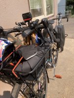
Now in Eugene I’ve been using the time to refit my bike. Decided all in all, the seat pack bikepacking bag wasn’t for me And isn’t durable for full-time life on the road. REI accepted the return for a refund. Bike is now fitted with a rear rack again and someone watching the Lael Rides Alaska grant stuff I was a finalist for, sent me some killer specialized edition gravel ortliebs to help my adventures along (seen on the back in photo below).
View attachment 66371
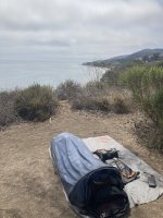
Plus I slapped a basket on the surly rack. Going to be heavier, but better fit for long-term stays. Also sold the bivy and decided to go back to a 1-person tent I can trust. Not sure what the future holds. Will likely go hobo up for some time on the Oregon coast where the sky lacks smoke and the temperature is cool. Amtrak isn’t running south until a week into September, so my back up plan is just to go to Slab City when that happens. I also met some other bike nomads who do weed trimming gigs up here I might tag along with for a bit. Living and working outside is pretty dependent on the fire season/ smoke here though. Hoping to get a work gig for a bit, but will settle on having a free to live winter. See y’all back out there soon!View attachment 66372
View attachment 66371
Plus I slapped a basket on the surly rack. Going to be heavier, but better fit for long-term stays. Also sold the bivy and decided to go back to a 1-person tent I can trust. Not sure what the future holds. Will likely go hobo up for some time on the Oregon coast where the sky lacks smoke and the temperature is cool. Amtrak isn’t running south until a week into September, so my back up plan is just to go to Slab City when that happens. I also met some other bike nomads who do weed trimming gigs up here I might tag along with for a bit. Living and working outside is pretty dependent on the fire season/ smoke here though. Hoping to get a work gig for a bit, but will settle on having a free to live winter. See y’all back out there soon!View attachment 66372
Attachments
ali
Well-known member
Wow, thank you so much for updating with your pics, they're awesome!
Firstly, i'm sorry you had some disappointing experiences meeting people from here. I used to hang with a lot of hippies when i was younger and although we were mostly aligned on general philosophies around environmentalism and temporary autonomous zones, i also found it disappointing that sometimes they had pretty conservative attitudes on sexuality and gender roles. I think it's really hard to find people who agree with you on a lot of issues. I have to admit i mostly gave up, and just accept people for whoever they are, even if their politics don't really mesh with mine. Perhaps that means i'm a sellout, but i just found it too exhausting to try debate people on stuff, or seek high and low for the vanishingly small number of folks who didn't hold some problematic views. Hell, some of my views are probably problematic too. My "trick" to deal with it nowadays is to avoid getting too close to people, so it's hard for anyone to really disappoint me. It's a bit of a lonely lifestyle, but it works for me at the moment.
That out of the way, i have questions!!
I was at a bike store the other day to pick up chain lube and was looking at the pedals. I saw those really skinny flat ones like you have - do you think it actually helps much? I thought it was weird that they had these little exposed screws. I only have one pair of shoes, they're my standard hiking shoes, will it totally bust up my soles if i try those flat pedals?
Also, all the stickers on your bike, are they easy to get off? Do you sell or give away the bike like that when you upgrade? I always avoid putting stickers on my stuff because i feel like if i kick it down to someone else they'll be annoyed i put stickers on it.
On the front-pannier setup you tried for a while... Does that help a lot for climbing? So far i have found that climbing on gravel "feels" easier than climbing on covered roads because the back wheel seems to dig in more, but i'm not sure if it's really because on gravel there's only one car going by every 20 minutes so it's easy to take up the whole road and have rests every time there is a switchback. I find the toughest climbs are on straight, sealed roads with lots of cars zooming past. I'm not sure if more weight on the front would make a difference, or just getting fitter is the main thing.
Thanks again for updating us all!